
Prediction of Rainfall-INduced landslides - Improving multi-scale TerritoriAL Early warning through aRTificial intelligence

Title: Prediction of Rainfall-INduced landslides - Improving multi-scale TerritoriAL Early warning through aRTificial intelligence (PRIN-ITALERT)
Scientific Person in Charge: Ascanio Rosi | Programme: PRIN 2022 DM 104/2022

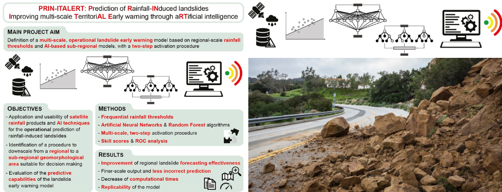
Predicting the occurrence of rainfall-induced landslides is a crucial task for civil protection purposes. Several landslide early warning systems are currently operating worldwide at different spatial scales, from local to regional. In Italy, landslide alerts are issued for territorial units named Alert Zones (AZ), covering a few thousand km2. Usually, regional-scale warning models rely on rainfall thresholds, which require a few parameters and provide clear results in short computational times. However, a regional-scale model, such as at AZ scale, may miss some local features that could be relevant for landslide initiation. This could hamper an effective warning by producing incorrect predictions (e.g. false alarms). For this reason, a multi-scale approach is required. The PRIN-ITALERT project (Prediction of Rainfall-INduced landslides - Improving multi-scale TerritoriAL Early warning through aRTificial intelligence) aims at improving the operational prediction of rainfall-induced landslides over large areas taking advantage of both rainfall thresholds defined using satellite-based rainfall products and innovative approaches based on artificial intelligence (AI)algorithms. In particular, the use of Random Forest and Artificial Neural Networks, two machine learning algorithms never adopted in operational landslide prediction, is foreseen. The project, proposed by a consortium of 3 research units, consists of 4 work packages. The main objective of PRIN-ITALERT is the definition of a multi-scale operational landslide prediction model based on regional-scale rainfall thresholds and AI-based sub-regional models, with a 2-step activation procedure. The rainfall thresholds are used as a first operational step of a multi-scale prediction model integrating AI-based algorithms, which will be activated only in case of threshold overcoming. The combination of both tools has the advantage of: 1)increasing the predicting effectiveness at a finer spatial resolution compared to the traditional regional-scale models; and 2) reducing the computational times. Two pilot areas frequently affected by geo-hydrological disasters and characterised by different geological and meteorological settings are selected: one in Liguria, north-western Italy, and another in Sicily, southern Italy. The project is expected to have relevant scientific, operational, and social impacts. A significant advancement of the state of the art concerning the spatial and temporal prediction of rainfall-induced landslides is foreseen; an improvement in the predictive capabilities of regional-scale models, also thanks to the multi-scale approach is expected, with a finer-scale output and a reduced lead-time, useful in hazard management and early warning activities. A key aspect of the proposal is that the developed methodology can be applied to other landslide-prone areas of the globe, as remote sensing rainfall data are now available in nearly real-time on a grid of global coverage.
Project partners: CNR-IRPI (coordinator), University of Padova, University of Firenze, University of Catania.