
Isola della Batteria: When the River Redraws the Land
The story of Isola della Batteria, in the Po Delta, almost seems imaginary. It has even been called “the island that doesn’t exist.” Yet until the 1960s, in Pila di Rovigo, it was home to a major 200-hectare farm. The island produced rice and offered employment and community for local residents.
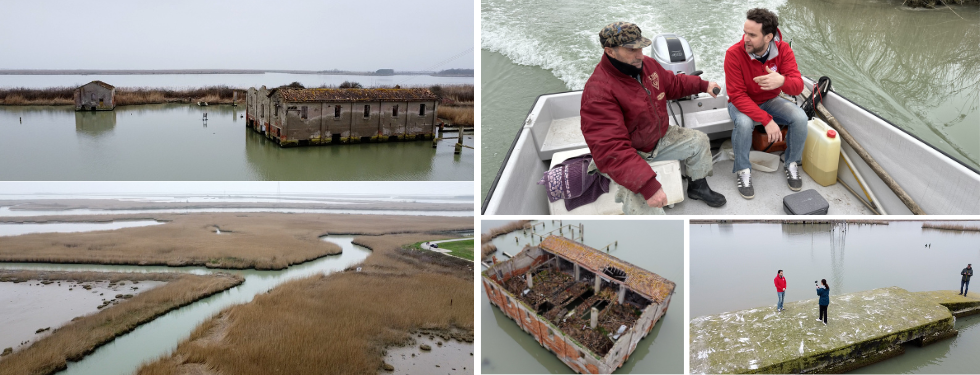
Everything changed in 1976, when a violent storm broke the levees and submerged the entire village. The masonry buildings were lost, but their ruins remain visible to this day, telling stories of the past.
Natale Mantovan, a fisherman who has lived in Pila di Rovigo all his life, stops his boat so we can look around. “Right here, we are above a drying yard where rice was laid out. But we also harvested reed plumes, the famous pennacchio, used to make brooms,” he explains. He points out the ruins in the distance and recounts their original functions.
There is a pumping station that once kept the land dry, military posts from World War II—hence the name “Batteria”—a rice warehouse, the guardian’s house, a small grocery store, and even a school. Teacher Cesarina Gobbi ran it for several years, ensuring that the children of local laborers received a basic education.
The Po Delta has always been a landscape of delicate balances between river dynamics and human activity. Intensive methane extraction in the 1940s and 1950s caused significant subsidence, accelerating natural sinking. Maintaining the island artificially became too costly. The valley was first turned to hunting and fishing and eventually abandoned.
By the late 1990s, however, something extraordinary happened. Alvise Finotello, a researcher at the Department of Geosciences specializing in rivers and deltas, explains: “A levee breach along the Po di Tramontana branch allowed river waters back into this area. Natural dynamics, blocked for decades, were restored. Over the past 30 years, the river has resumed what it has always done: depositing sediment and creating hundreds of thousands of square meters of new land.”
In just a few decades, the river has compensated for both rising sea levels and land subsidence. Sediment layers in some areas now exceed two meters in thickness.
These processes are being studied in the NatResPoNΔ project (Nature-based Solutions for building land and mitigating subsidencE). Conducted by the Department of Geosciences at the University of Padua and the Institute of Geosciences and Georesources of the National Research Council, the project is funded by the European Union through Next Generation EU and the Italian Ministry of University and Research under the PNRR program.
The team uses a multidisciplinary approach—sediment analysis, topographic and bathymetric surveys, remote sensing, and advanced numerical modeling—to build a hydromorphodynamic model. It simulates what happens when the river reconnects with its floodplains and evaluates controlled sediment diversion scenarios.
“The goal is not to turn back time,” Finotello explains, “but to understand, in quantitative terms, what happens when natural processes interrupted for decades are reactivated.” He coordinates the project with Valentina Rossi (IGG-CNR).
Another key finding is the role of newly formed wetlands on the island.
“These wetlands capture not only mineral sediment, like river-borne sand, but also organic matter. Even though they are very young, they already function like mature ecosystems, with carbon stocks comparable to much older coastal wetlands. This means that, in addition to building new land, they actively sequester carbon from the atmosphere—offering real opportunities in the fight against climate change,” Finotello notes.
More than a lost place, Isola della Batteria now proves that nature, when given space, can redraw the landscape. It creates new balances between water and land, while offering concrete ways to meet today’s environmental challenges.
Article written by Barbara Paknazar
Video shooting and editing by Barbara Paknazar
Drone footage by Stefano Castelli